


KALLIOPI
DEPTH: 49 - 60 m
SKILL: Expert
Kalliopi (ex-Robert Dale Owen); cargo steamship, Liberty class; Greek, Panagos D. Pateras company from the island of Chios
Built: May 1943
Sunk: 20th December 1947 (navigational error – hit a mine)
Dimensions: l=133 m, w=15 m
Coordinates: 45.15563° N, 14.27088° E
Location: about 800 m W of the Cape of Jablanac
Access: 2/5 access is possible only by boat
Visibility: 3/5 good, occasionally very good
Current: 3/5 average, occasionally strong
Flora and fauna: 4/5 varied life on and around the wreck, occasionally specimens of larger fish and crabs
HISTORY:
In 1941 the Americans chose the Liberty programme as the most suitable for the fast expansion of their merchant fleet. 18 new shipyards were built and thousands of workers were trained for work in serial production. The first ship of the Liberty Patrick Henry class was launched into the sea on 27th September 1941, and was finished by 30th December 1941, and mid-war production was shortened to just twenty days!
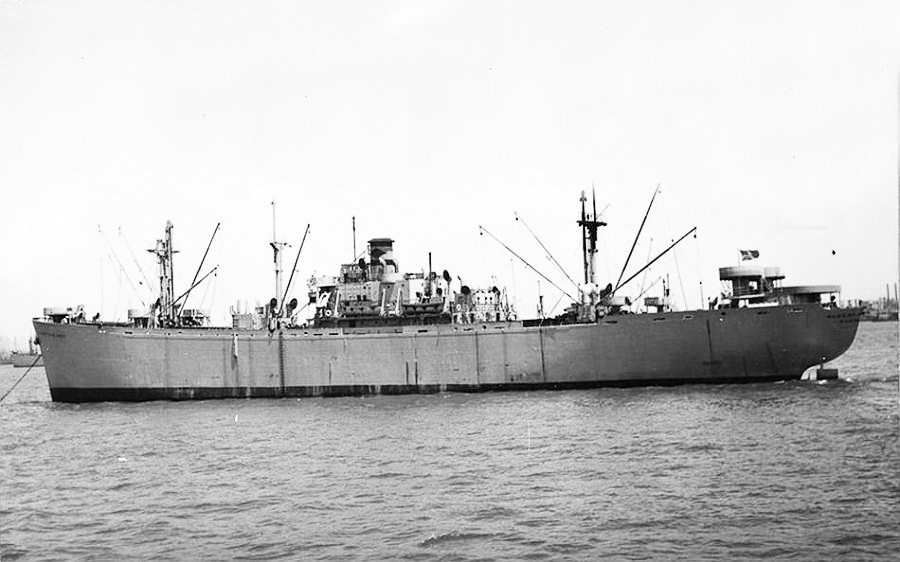
In the Second World War a total of 2,710 ships were built in the Liberty class, of which a large number survived the war. Greek ship owners bought a large number of Liberties from the American war surplus and established numerous maritime companies. This was also the destiny of the ship the Robert Dale Owen. Until the end of the war it sailed for the American Army as a transport ship for the carrying of troops, after which it was decommissioned and put up for sale. In 1946 the company Panagos D. Pateras from the Greek island of Chios bought it and gave it a name from Greek mythology - Kalliopi.
The Kalliopi happily sailed the seas of the world for more than a year, trade routes also brought it to the Adriatic. Sailing empty (in ballast) from Charleston to Rijeka it stopped briefly in Ancona. On 20th December the Kalliopi passed into Kvarnerić. At that time Kvarner and Kvarnerić were only partially cleared of mines left over from the war, so all the ships which had sailed through Kvarner had to strictly abide by the instructions about the use of the safety corridor for the movement of ships.
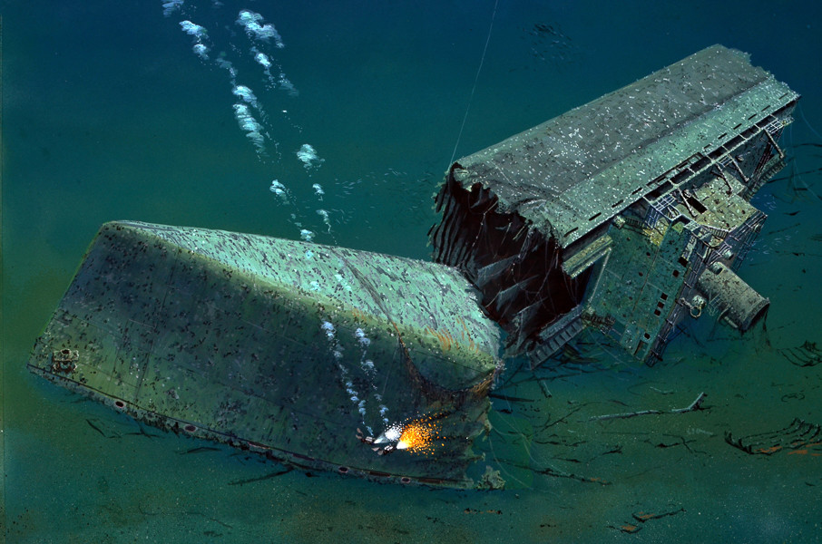
At about 0700 hrs. the Kalliopi arrived at the entrance of Vela Vrata. It seemed that the ship would pass safely through the channel, however when the ship was almost at the exist of the channel, at 0740 hrs. a tall column of water rose from the sea along the flank of the ship, and at the same time a powerful explosion reverberated, the ship began to visibly lean. The ship’s structure creaked dangerously because of the twisting of the hull, but the ship somehow held itself at the surface. Lowering the lifeboats, the crew got into them and pushed themselves away from the sinking ship. In that moment the stern section broke away from the rest of the ship and soon sank, whilst the bow section, already mostly under the water, was carried slowly southwards by the current. The Kalliopi slowly began to disappear from the surface of the middle of the channel.
WRECK CONDITION AND DIVING:
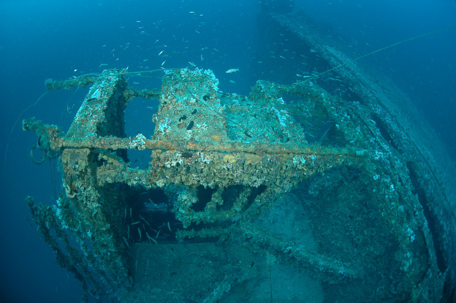
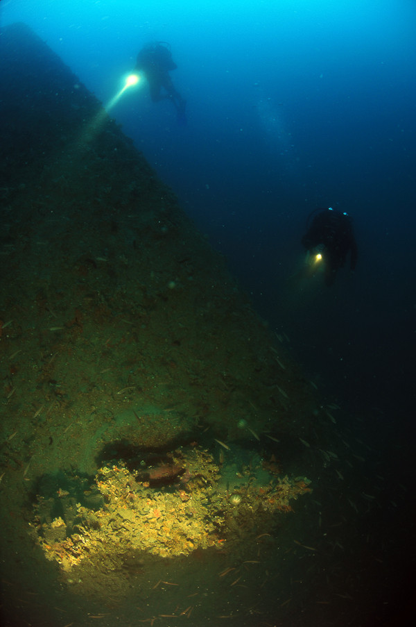
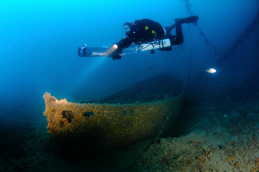
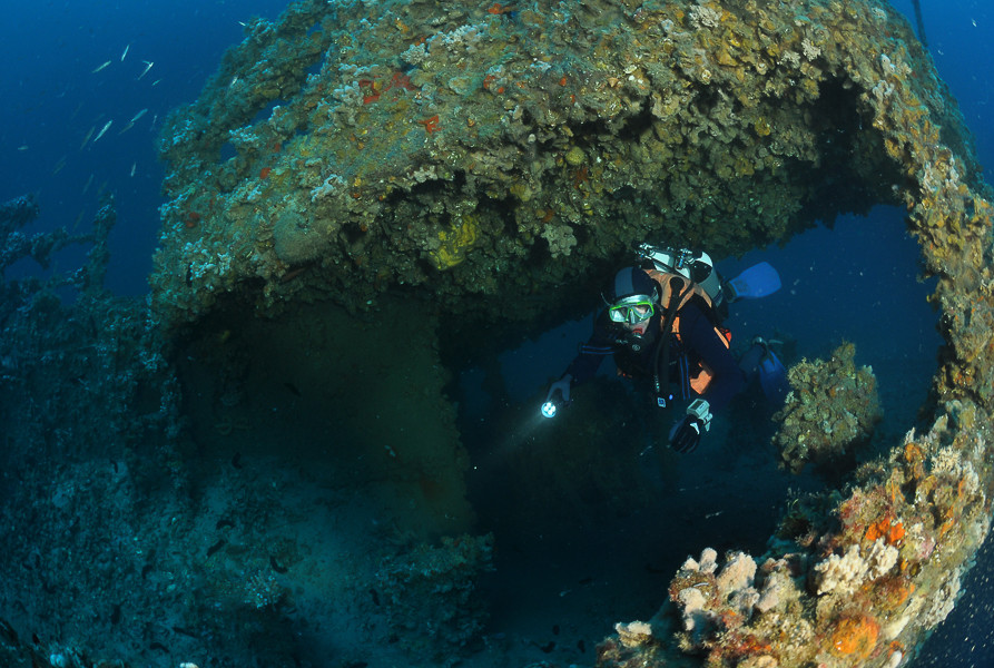
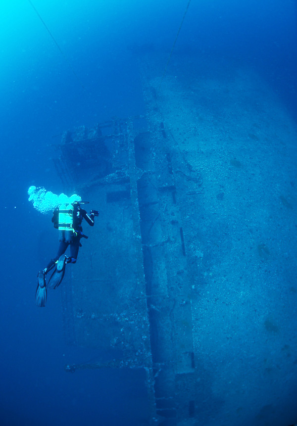
The wreck is situated in the middle of the Vela Vrata Channel. The ship is broken into three parts, of which the front section – the bow, lies on the bottom with its keel towards the surface, whilst the middle section with the superstructure lies on its left side, twenty metres or so away from the bow. The stern section sank northerly and further away almost a mile from the main wreck. Due to its large cargo capacity, the hull is distinctly cut into rectangular sections. The highest part of the ship is somewhat deeper than 40 metres. The whole superstructure is clearly visible, and in front of and behind the superstructure the ship is completely split.
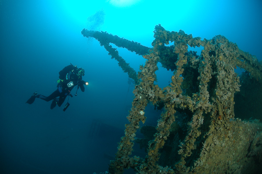
On the superstructure the rail is in good condition, as are the stairs which lead from the bridge down to the deck. On the superstructure are several open doors, and it is also possible to enter into the interior of the bridge. On the roof of the bridge are still the direction finder antenna and the pedestal for the compass, and in the middle of the roof rises the funnel, which is firmly in place. The lifeboats davits are in a skewed position, which is a clear sign that the boats were lowered into the sea before the sinking.
The description and illustrations are a courtesy of Danijel Frka and Jasen Mesić. Buy the whole book here: https://shop.naklada-val.hr/product_info.php?products_id=561
Built: May 1943
Sunk: 20th December 1947 (navigational error – hit a mine)
Dimensions: l=133 m, w=15 m
Coordinates: 45.15563° N, 14.27088° E
Location: about 800 m W of the Cape of Jablanac
Access: 2/5 access is possible only by boat
Visibility: 3/5 good, occasionally very good
Current: 3/5 average, occasionally strong
Flora and fauna: 4/5 varied life on and around the wreck, occasionally specimens of larger fish and crabs
HISTORY:
In 1941 the Americans chose the Liberty programme as the most suitable for the fast expansion of their merchant fleet. 18 new shipyards were built and thousands of workers were trained for work in serial production. The first ship of the Liberty Patrick Henry class was launched into the sea on 27th September 1941, and was finished by 30th December 1941, and mid-war production was shortened to just twenty days!
In the Second World War a total of 2,710 ships were built in the Liberty class, of which a large number survived the war. Greek ship owners bought a large number of Liberties from the American war surplus and established numerous maritime companies. This was also the destiny of the ship the Robert Dale Owen. Until the end of the war it sailed for the American Army as a transport ship for the carrying of troops, after which it was decommissioned and put up for sale. In 1946 the company Panagos D. Pateras from the Greek island of Chios bought it and gave it a name from Greek mythology - Kalliopi.
The Kalliopi happily sailed the seas of the world for more than a year, trade routes also brought it to the Adriatic. Sailing empty (in ballast) from Charleston to Rijeka it stopped briefly in Ancona. On 20th December the Kalliopi passed into Kvarnerić. At that time Kvarner and Kvarnerić were only partially cleared of mines left over from the war, so all the ships which had sailed through Kvarner had to strictly abide by the instructions about the use of the safety corridor for the movement of ships.
At about 0700 hrs. the Kalliopi arrived at the entrance of Vela Vrata. It seemed that the ship would pass safely through the channel, however when the ship was almost at the exist of the channel, at 0740 hrs. a tall column of water rose from the sea along the flank of the ship, and at the same time a powerful explosion reverberated, the ship began to visibly lean. The ship’s structure creaked dangerously because of the twisting of the hull, but the ship somehow held itself at the surface. Lowering the lifeboats, the crew got into them and pushed themselves away from the sinking ship. In that moment the stern section broke away from the rest of the ship and soon sank, whilst the bow section, already mostly under the water, was carried slowly southwards by the current. The Kalliopi slowly began to disappear from the surface of the middle of the channel.
WRECK CONDITION AND DIVING:
The wreck is situated in the middle of the Vela Vrata Channel. The ship is broken into three parts, of which the front section – the bow, lies on the bottom with its keel towards the surface, whilst the middle section with the superstructure lies on its left side, twenty metres or so away from the bow. The stern section sank northerly and further away almost a mile from the main wreck. Due to its large cargo capacity, the hull is distinctly cut into rectangular sections. The highest part of the ship is somewhat deeper than 40 metres. The whole superstructure is clearly visible, and in front of and behind the superstructure the ship is completely split.
On the superstructure the rail is in good condition, as are the stairs which lead from the bridge down to the deck. On the superstructure are several open doors, and it is also possible to enter into the interior of the bridge. On the roof of the bridge are still the direction finder antenna and the pedestal for the compass, and in the middle of the roof rises the funnel, which is firmly in place. The lifeboats davits are in a skewed position, which is a clear sign that the boats were lowered into the sea before the sinking.
The description and illustrations are a courtesy of Danijel Frka and Jasen Mesić. Buy the whole book here: https://shop.naklada-val.hr/product_info.php?products_id=561
INVESTMENTS
 H2O Globe BETA
was successfully backed by an amazing group of diving lovers from all around the world!
