


VASSILIOS T.
DEPTH: 25 - 55 m
SKILL: Advanced
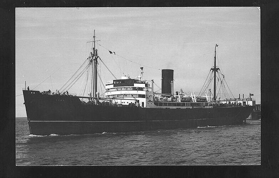
Vassilios T. (ex-Eastern Temple/USA); cargo steamship; Greek
Built: 1920, Nitta Shipyard, Osaka, Japan
Sunk: 19th March 1939 (collision with the coast and ran aground)
Dimensions: l=104 m, w=15.1 m, h=8.7 m, 3,673 GRT, 2,236 NRT
Coordinates: 43.00458° N, 16.06517° E
Location: Cape of Stupišće, SW of Komiža, island of Vis
Access: 3/5 access is possible by boat and from the land (somewhat difficult)
Visibility: 4-5/5 mostly very good to excellent
Current: 4/5 mostly weak
Flora and fauna: 5/5 varied life on and around the wreck, occasionally specimens of large fish
HISTORY:
There is not much known about the cargo steamship Vassilios T., except that it was built in the Japanese Nitta shipyard in Osaka in Japan and that it was ordered by the American company High Seas Transportation Inc. from New York and that it sailed for that company under the name of the Eastern Temple. In 1938 the company sold it to Eleftherios M.Tricoglu a Greek ship owner from the island of Andros. However in the new owner’s fleet it did not sail for long. It perished on the night of 19th March 1939 on the way from Swansea to Venice, transporting a cargo of coal. It was probably due to a navigational error and negligence, that it ran aground on the outer part of the Cape of Stupišće and after some time it sank, lying on its left side. Some information, although unchecked, says that the crew deliberately caused the shipwreck and the loss of the ship and the entire cargo, so that the owner could claim on the high insurance (not a rare case at that time).
WRECK CONDITION AND DIVING:
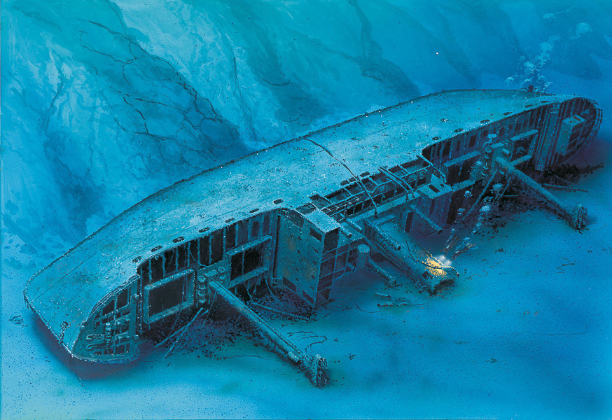
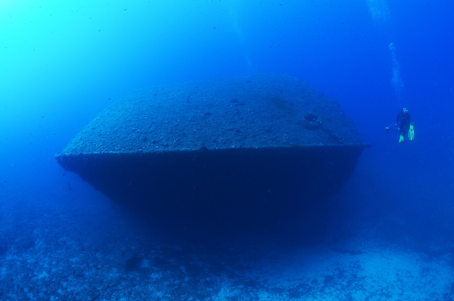
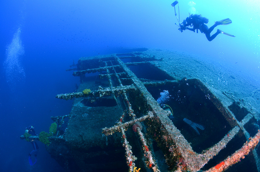
The wreck of the Vassilios is not difficult to reach. We only need to anchor at the little concrete pier at the foot of the lighthouse on the western side of the Cape of Stupišće, from where the wreck is just twenty metres. If the winds are coming from the northwest or west or even if there is the “bura” wind, it is best to anchor behind the cape (south side), which is then the leeward side. After preparations on the boat, or even more comfortable, on the land at the foot of the lighthouse, we need to dive to the depths keeping slightly to the left (towards the southwest). First of all, at a depth of about 18 metres, we will come across a large bow anchor, next to which is a block with a rope and a buoy to which diving centres’ boats are tied. Following the chain which from the anchor leads towards the ship, just after a few metres in front of us emerges the huge flat bow of a large ship, with its keel turned towards the land. When we swim closer, in the very clear sea we will see the entire front section of the ship which lies on its left side. The port anchor is still in place. On the bow the large anchor windlass is overgrown with yellow sponges. Underneath it the wooden deck has rotten away, as with many other ships from this time, so that through the metal frames the whole of the bow interior can be seen. With very good visibility, along the ship on the seabed can be seen piles of coal which had been strewn from the ship’s cargo hold.
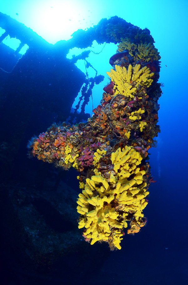
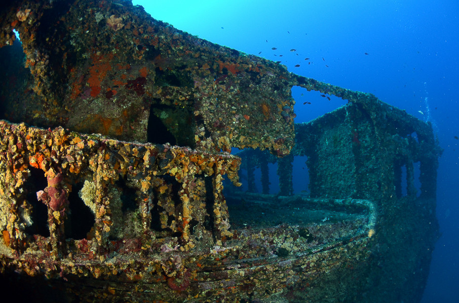
Diving towards the superstructure that is still well-preserved we see the foremast, still firmly in its place. On the top is a cylindrical crow’s nest, completely overgrown with yellow sulphur sponges. The bridge has disappeared, as it was surely a wooden structure. In the place of the wheelhouse until several years ago there still existed the metal helm which could even be moved. Unfortunately, today it is no more, which is testimony to the fact that unscrupulous souvenir collectors still operate whose passion is greater than their consciousness for preserving historical treasures. There are also no longer any wooden floors on the superstructure which divided the storeys between the decks, and so many internal areas can be visited without passing through dangerous narrow passages.
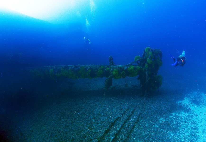
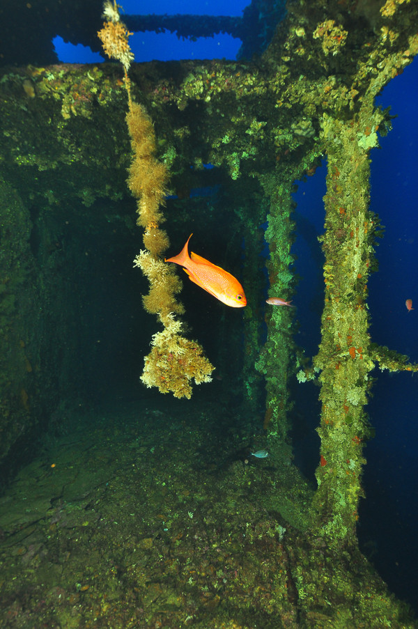
Inside the superstructure large groupers and conger eels are regularly encountered, and the whole of the superstructure is overgrown with yellow and orange sponges. The stern section of the ship is somewhat deeper, since the ship is lying at the bottom which from the cape slopes down towards the west into the depths. The rear cargo holds are spacious and through them it is also possible to view the interior of the ship. In them are the remains of the cargo of coal which is also scattered over the bottom here. The bottom beneath the stern is at a depth of 55 metres, and the clear sea gives the impression as though the depth is much less. On the return towards the bow section of the ship, if we swim above the starboard side, at the middle of the hull at the level of the superstructure we will see damage in the form of two vertical cracks, where the main damage was made and where the sea came into the ship causing the sinking. The lifeboat davits are still in place on the deck. They are partially twisted which shows that the crew had tried to lower the boats, which was a difficult and dangerous job on the listing and slippery deck. Along the starboard side is the rocky Cape of Stupišće which gently climbs towards the surface. This is also the safest way that we can follow towards the place where we dived.
The description and illustrations are a courtesy of Danijel Frka and Jasen Mesić. Buy the whole book here: https://shop.naklada-val.hr/product_info.php?products_id=561
Built: 1920, Nitta Shipyard, Osaka, Japan
Sunk: 19th March 1939 (collision with the coast and ran aground)
Dimensions: l=104 m, w=15.1 m, h=8.7 m, 3,673 GRT, 2,236 NRT
Coordinates: 43.00458° N, 16.06517° E
Location: Cape of Stupišće, SW of Komiža, island of Vis
Access: 3/5 access is possible by boat and from the land (somewhat difficult)
Visibility: 4-5/5 mostly very good to excellent
Current: 4/5 mostly weak
Flora and fauna: 5/5 varied life on and around the wreck, occasionally specimens of large fish
HISTORY:
There is not much known about the cargo steamship Vassilios T., except that it was built in the Japanese Nitta shipyard in Osaka in Japan and that it was ordered by the American company High Seas Transportation Inc. from New York and that it sailed for that company under the name of the Eastern Temple. In 1938 the company sold it to Eleftherios M.Tricoglu a Greek ship owner from the island of Andros. However in the new owner’s fleet it did not sail for long. It perished on the night of 19th March 1939 on the way from Swansea to Venice, transporting a cargo of coal. It was probably due to a navigational error and negligence, that it ran aground on the outer part of the Cape of Stupišće and after some time it sank, lying on its left side. Some information, although unchecked, says that the crew deliberately caused the shipwreck and the loss of the ship and the entire cargo, so that the owner could claim on the high insurance (not a rare case at that time).
WRECK CONDITION AND DIVING:
The wreck of the Vassilios is not difficult to reach. We only need to anchor at the little concrete pier at the foot of the lighthouse on the western side of the Cape of Stupišće, from where the wreck is just twenty metres. If the winds are coming from the northwest or west or even if there is the “bura” wind, it is best to anchor behind the cape (south side), which is then the leeward side. After preparations on the boat, or even more comfortable, on the land at the foot of the lighthouse, we need to dive to the depths keeping slightly to the left (towards the southwest). First of all, at a depth of about 18 metres, we will come across a large bow anchor, next to which is a block with a rope and a buoy to which diving centres’ boats are tied. Following the chain which from the anchor leads towards the ship, just after a few metres in front of us emerges the huge flat bow of a large ship, with its keel turned towards the land. When we swim closer, in the very clear sea we will see the entire front section of the ship which lies on its left side. The port anchor is still in place. On the bow the large anchor windlass is overgrown with yellow sponges. Underneath it the wooden deck has rotten away, as with many other ships from this time, so that through the metal frames the whole of the bow interior can be seen. With very good visibility, along the ship on the seabed can be seen piles of coal which had been strewn from the ship’s cargo hold.
Diving towards the superstructure that is still well-preserved we see the foremast, still firmly in its place. On the top is a cylindrical crow’s nest, completely overgrown with yellow sulphur sponges. The bridge has disappeared, as it was surely a wooden structure. In the place of the wheelhouse until several years ago there still existed the metal helm which could even be moved. Unfortunately, today it is no more, which is testimony to the fact that unscrupulous souvenir collectors still operate whose passion is greater than their consciousness for preserving historical treasures. There are also no longer any wooden floors on the superstructure which divided the storeys between the decks, and so many internal areas can be visited without passing through dangerous narrow passages.
Inside the superstructure large groupers and conger eels are regularly encountered, and the whole of the superstructure is overgrown with yellow and orange sponges. The stern section of the ship is somewhat deeper, since the ship is lying at the bottom which from the cape slopes down towards the west into the depths. The rear cargo holds are spacious and through them it is also possible to view the interior of the ship. In them are the remains of the cargo of coal which is also scattered over the bottom here. The bottom beneath the stern is at a depth of 55 metres, and the clear sea gives the impression as though the depth is much less. On the return towards the bow section of the ship, if we swim above the starboard side, at the middle of the hull at the level of the superstructure we will see damage in the form of two vertical cracks, where the main damage was made and where the sea came into the ship causing the sinking. The lifeboat davits are still in place on the deck. They are partially twisted which shows that the crew had tried to lower the boats, which was a difficult and dangerous job on the listing and slippery deck. Along the starboard side is the rocky Cape of Stupišće which gently climbs towards the surface. This is also the safest way that we can follow towards the place where we dived.
The description and illustrations are a courtesy of Danijel Frka and Jasen Mesić. Buy the whole book here: https://shop.naklada-val.hr/product_info.php?products_id=561
INVESTMENTS
 H2O Globe BETA
was successfully backed by an amazing group of diving lovers from all around the world!
