


ARMED BRIG
DEPTH: 52 - 54 m
SKILL: Expert
Sailing ship, wooden construction, probably brig type; affiliation unknown, possibly Genoese
Built: 18th century (?)
Sunk: unknown
Dimensions: l= about 34 m, w=about 5 m
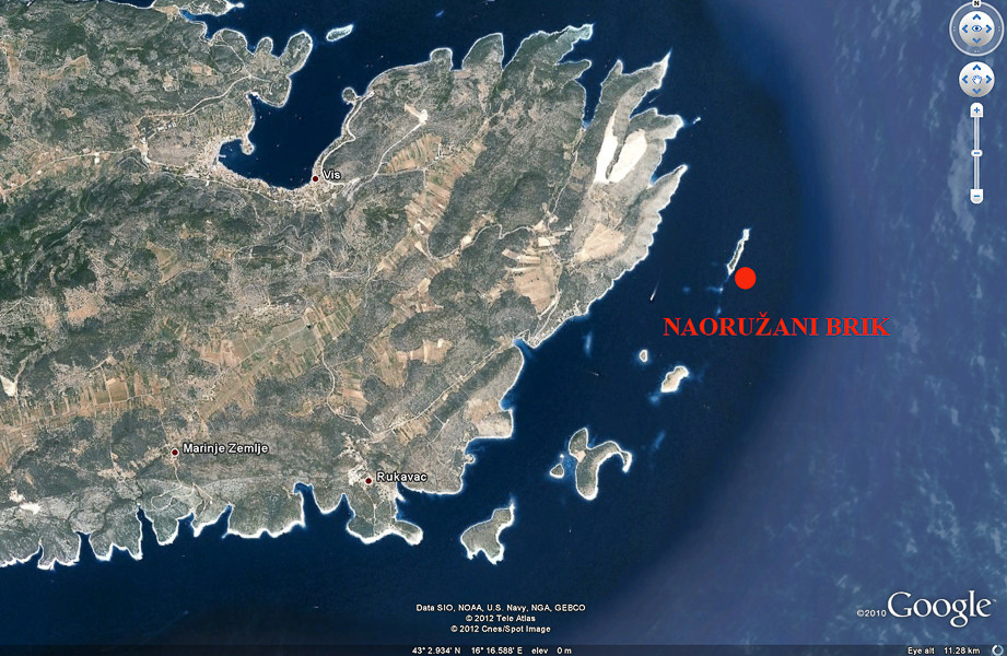
coordinates: 43.04800° N, 16.26667° E
Location: S edge of the islet of Greben, SE side of the island of Vis
Access: 2/5 access is possible solely by boat (the location is alongside the uninhibited islet)
Visibility: 5/5 mostly very good visibility
Current: 4/5 weak, only occasionally moderate
Flora and fauna: 4/5 varied life on and around the wreck
HISTORY:
This location was found as late as the beginning of the 1980’s. Due to the relatively great depths and because diving was not permitted due to military reasons, it was not accessible to most divers and so therefore it remained untouched, which is rare in similar locations. It was found by diver Sergio Gobbo and the divers from an advanced diving club and immediately a preliminary investigation was carried out by the Institute for the Protection of Cultural Monuments. During the investigation it was established that the find was very important and rare, because some elements suggested that it was a warship from the beginning of the 19th century.
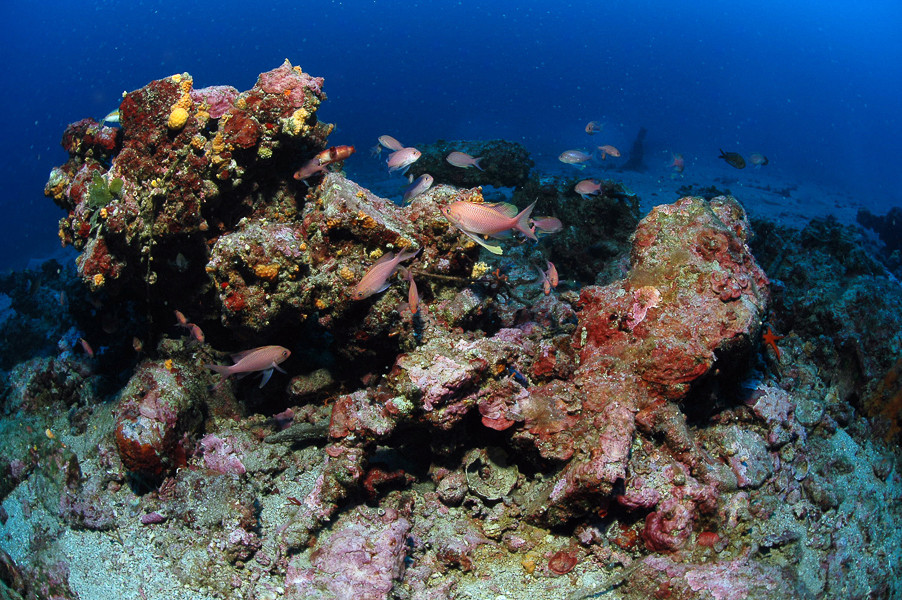
The location is situated at the southern end of the island, which indicates that the ship most probably sank at the time of a strong southerly wind or maybe during the night when it carelessly approached the harbour of Vis. Prolonged exposure of the wooden hull to the warm sea water (rich in organisms which destroy wood, especially worms of the Terredo navalis family) have meant that almost nothing remains of the wooden parts, except those parts which have been above the sand. Therefore the location of the shipwreck can be recognised by the ship’s equipment, and in this case our sailing ship was first of all recognised by its cannons.
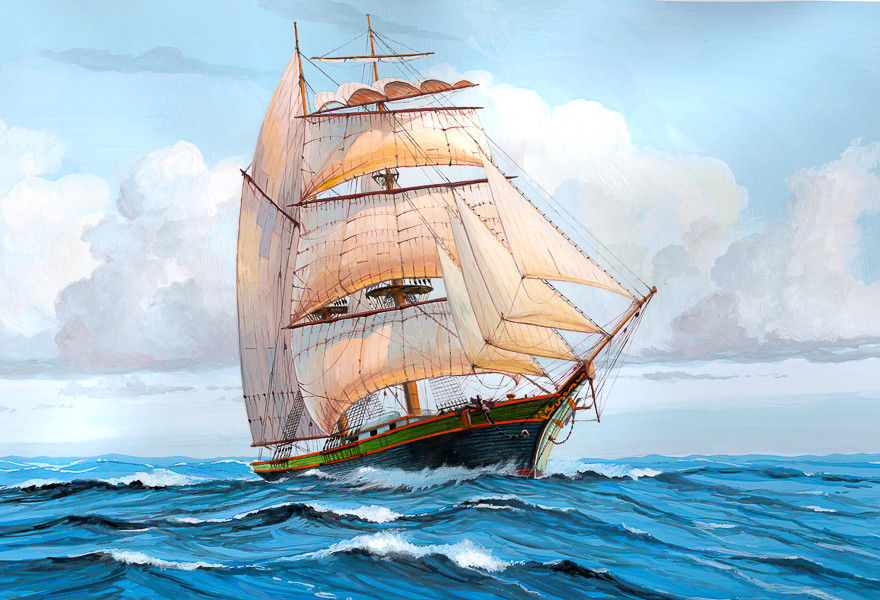
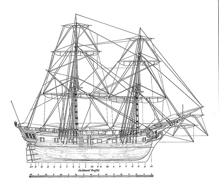
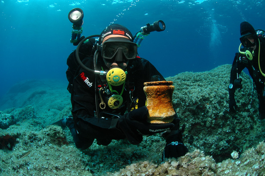
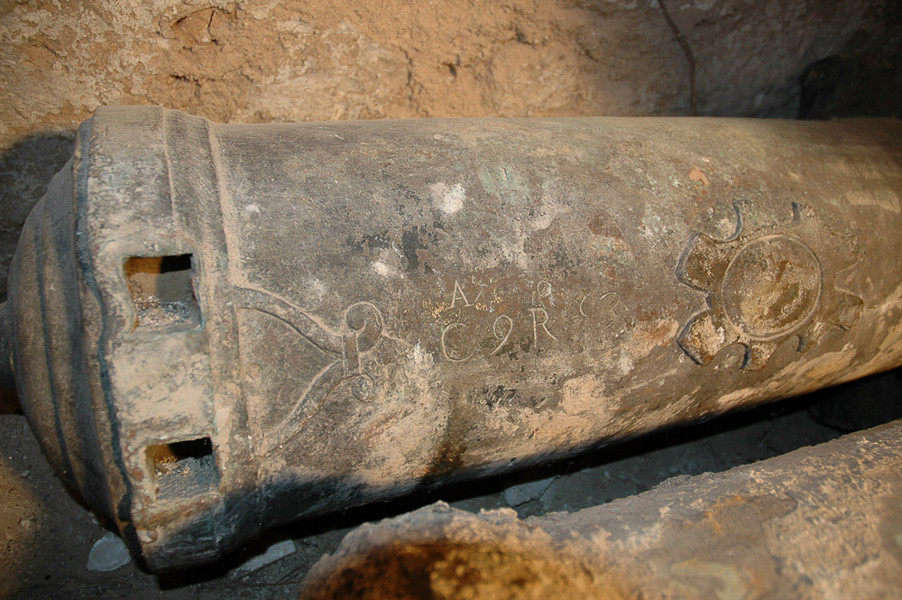
Our ship was armed with 16 cannons, of which two were made from bronze, and the rest from iron. The bronze cannons were removed under the supervision of the Department of Hydro-Archaeology at the time of the exploration of the site, whilst the remaining cannons and other equipment were left at the site of the find. The removed cannons were placed in Vis’s museum where they can be seen today. Regarding the armaments and their dimensions, it is possible that this ship is a type of brig. These were ships of high speed, small tonnage, and with two masts. They were used by the merchant fleets and by navies. Is it possible that the ship is of French origins, meanwhile the latest research suggests that the bronze cannons were cast in the area of Genoa in Italy. A more detailed exploration of the ship which could give answers to some of these uncertainties has been postponed until further notice.
WRECK CONDITION AND DIVING:
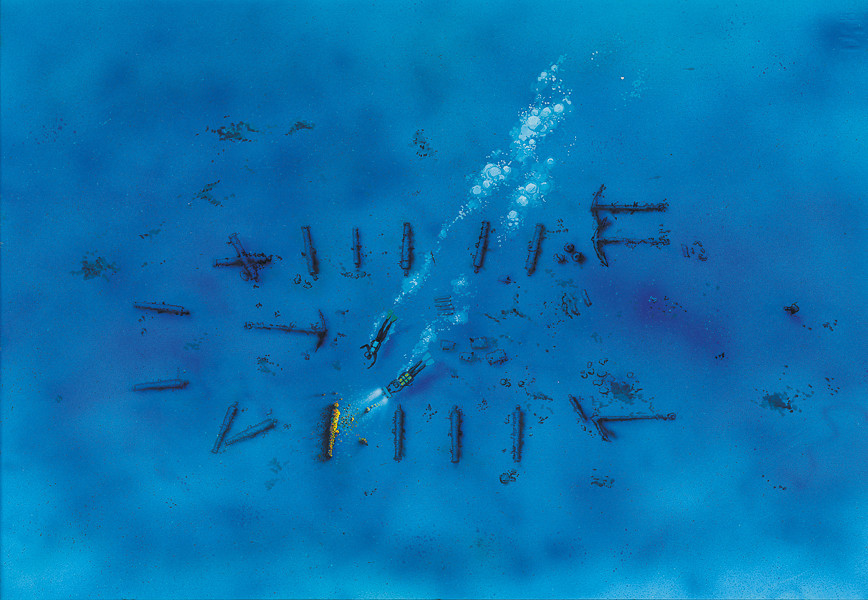
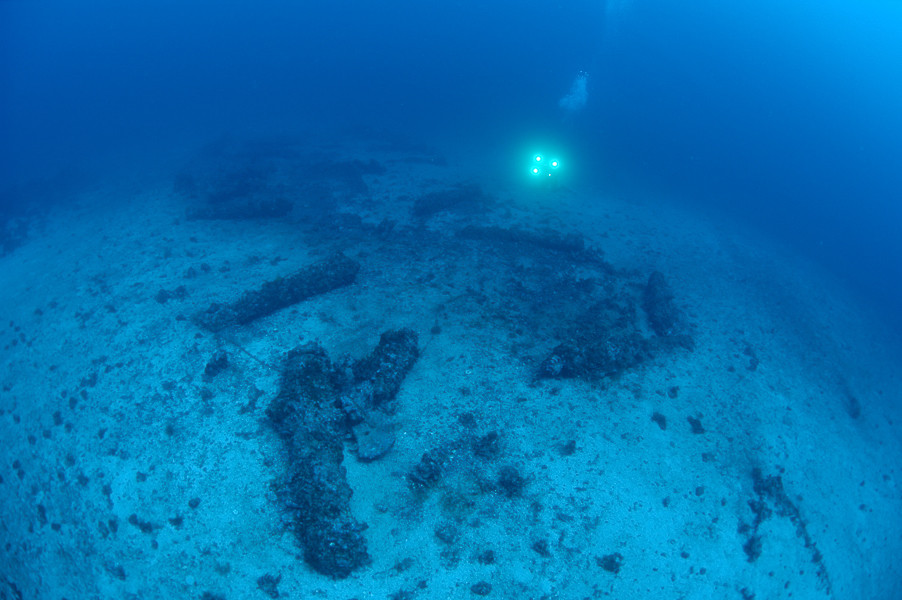
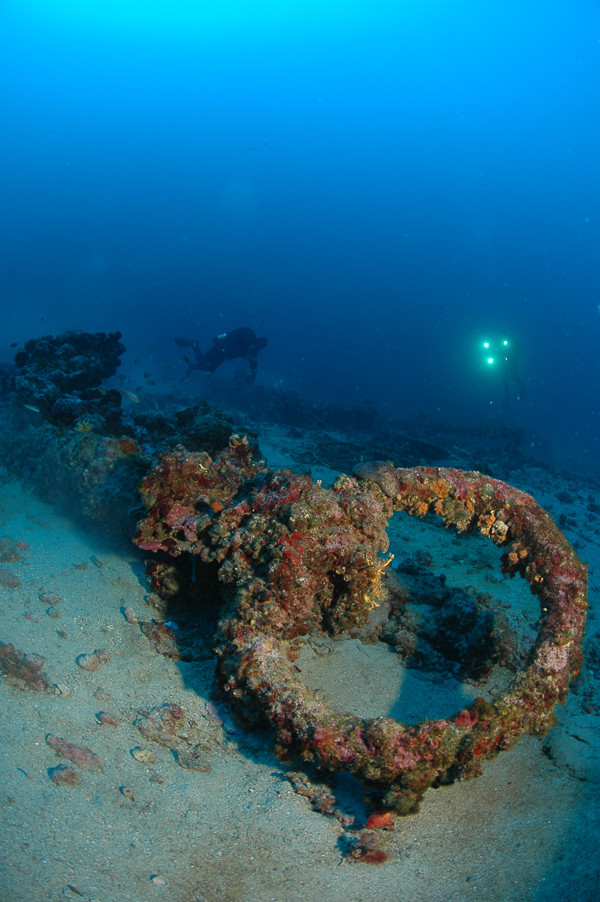
The ship sank in an upright position, and it still lies in that position on the seabed today. Diving towards the ship begins down a steep rocky slope, at the foot of which lies the wreck. At a depth of about 25 metres dark oblong objects can be seen on the seabed. These are the cannons, which lie on the bottom exactly as they were secured to the ship’s deck. Upon the descent to the wreck one should therefore stop several metres above the ship so as to best see the outline of its hull.
Although the seabed is sandy, one should descend slowly, as any movement of flippers could stir up a large cloud of sand and so reduce visibility, which is otherwise excellent, as with all other localities around Vis. On the part of the ship which is turned towards the south are located three large anchors, and on the opposite end there is one more. In the surroundings of the wreck can been seen large surmullets which mingle about in large numbers in the sand. Here and there they uncover some wooden piece of the ship or pieces of its inventory which have lain under the sand. The return along the steep cliffs is also interesting because the cliffs are full of vertical and horizontal cracks and holes with an abundance of fish.
For the thorough investigation of the ship it would be necessary to remove the layer of sand from the central part of the wreck and then reach the bottom of the ship’s hull. What could be found at that occasion, can only be speculated, however that would require special equipment and a professional team
Note: The wreck of is located in a protected zone which means that diving on it is not allowed without an authorised diving centre. The removal of any kind of object is not allowed at the location or around it.
The description and illustrations are a courtesy of Danijel Frka and Jasen Mesić. Buy the whole book here: https://shop.naklada-val.hr/product_info.php?products_id=561
Built: 18th century (?)
Sunk: unknown
Dimensions: l= about 34 m, w=about 5 m
coordinates: 43.04800° N, 16.26667° E
Location: S edge of the islet of Greben, SE side of the island of Vis
Access: 2/5 access is possible solely by boat (the location is alongside the uninhibited islet)
Visibility: 5/5 mostly very good visibility
Current: 4/5 weak, only occasionally moderate
Flora and fauna: 4/5 varied life on and around the wreck
HISTORY:
This location was found as late as the beginning of the 1980’s. Due to the relatively great depths and because diving was not permitted due to military reasons, it was not accessible to most divers and so therefore it remained untouched, which is rare in similar locations. It was found by diver Sergio Gobbo and the divers from an advanced diving club and immediately a preliminary investigation was carried out by the Institute for the Protection of Cultural Monuments. During the investigation it was established that the find was very important and rare, because some elements suggested that it was a warship from the beginning of the 19th century.
The location is situated at the southern end of the island, which indicates that the ship most probably sank at the time of a strong southerly wind or maybe during the night when it carelessly approached the harbour of Vis. Prolonged exposure of the wooden hull to the warm sea water (rich in organisms which destroy wood, especially worms of the Terredo navalis family) have meant that almost nothing remains of the wooden parts, except those parts which have been above the sand. Therefore the location of the shipwreck can be recognised by the ship’s equipment, and in this case our sailing ship was first of all recognised by its cannons.
Our ship was armed with 16 cannons, of which two were made from bronze, and the rest from iron. The bronze cannons were removed under the supervision of the Department of Hydro-Archaeology at the time of the exploration of the site, whilst the remaining cannons and other equipment were left at the site of the find. The removed cannons were placed in Vis’s museum where they can be seen today. Regarding the armaments and their dimensions, it is possible that this ship is a type of brig. These were ships of high speed, small tonnage, and with two masts. They were used by the merchant fleets and by navies. Is it possible that the ship is of French origins, meanwhile the latest research suggests that the bronze cannons were cast in the area of Genoa in Italy. A more detailed exploration of the ship which could give answers to some of these uncertainties has been postponed until further notice.
WRECK CONDITION AND DIVING:
The ship sank in an upright position, and it still lies in that position on the seabed today. Diving towards the ship begins down a steep rocky slope, at the foot of which lies the wreck. At a depth of about 25 metres dark oblong objects can be seen on the seabed. These are the cannons, which lie on the bottom exactly as they were secured to the ship’s deck. Upon the descent to the wreck one should therefore stop several metres above the ship so as to best see the outline of its hull.
Although the seabed is sandy, one should descend slowly, as any movement of flippers could stir up a large cloud of sand and so reduce visibility, which is otherwise excellent, as with all other localities around Vis. On the part of the ship which is turned towards the south are located three large anchors, and on the opposite end there is one more. In the surroundings of the wreck can been seen large surmullets which mingle about in large numbers in the sand. Here and there they uncover some wooden piece of the ship or pieces of its inventory which have lain under the sand. The return along the steep cliffs is also interesting because the cliffs are full of vertical and horizontal cracks and holes with an abundance of fish.
For the thorough investigation of the ship it would be necessary to remove the layer of sand from the central part of the wreck and then reach the bottom of the ship’s hull. What could be found at that occasion, can only be speculated, however that would require special equipment and a professional team
Note: The wreck of is located in a protected zone which means that diving on it is not allowed without an authorised diving centre. The removal of any kind of object is not allowed at the location or around it.
The description and illustrations are a courtesy of Danijel Frka and Jasen Mesić. Buy the whole book here: https://shop.naklada-val.hr/product_info.php?products_id=561
INVESTMENTS
 H2O Globe BETA
was successfully backed by an amazing group of diving lovers from all around the world!
