


TETI
DEPTH: 10 - 34 m
SKILL: All
Teti (ex-Acorean/PT, ex-Caiala, ex-Magna, ex-Udsire, ex-Archiduc Rodolphe/AM);
cargo steamship; Societa Italiana Navigazione Trasporti e Armamenti Ravenna, Italy
Built: 1883, John Cockerill shipyard, Hoboken, USA
Sunk: 23rd May 1930 (navigational error – ran aground on the islet of Mali Barjak)
Dimensions: l=72 m, w=8 m, h=4.8 m, 963 t
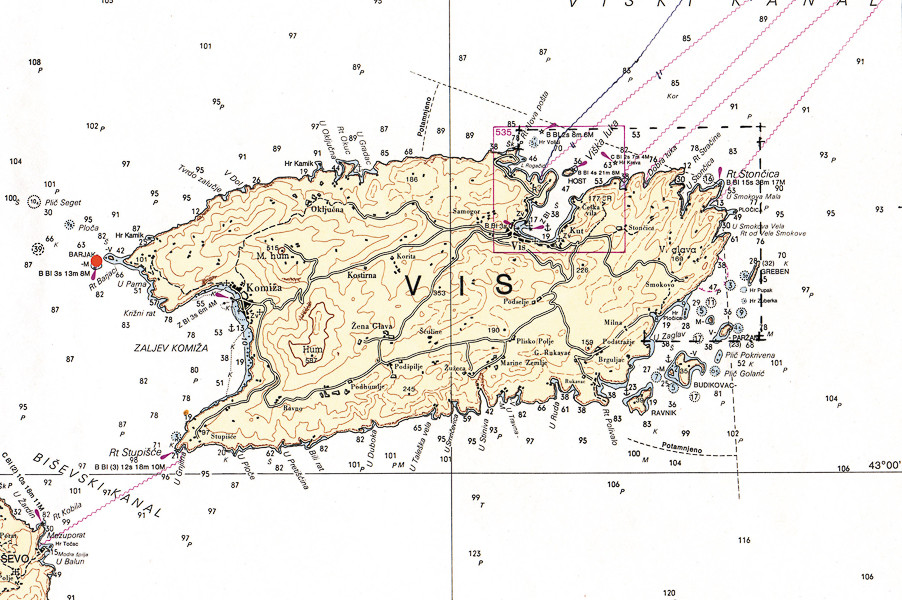
Coordinates: 43.05333° N, 16.04100° E
Location: Mali Barjak, island of Vis, western cape of Komiža cove
Access: 2/5 access is possible solely by boat (the location is alongside the islet)
Visibility: 5/5 mostly excellent
Current: 5/5 mostly weak
Flora and fauna: 5/5 varied life on and around the wreck, occasionally specimens of large fish (conger eels)
HISTORY:
It was a dark and stormy May night. The residents of Komiža had just dozed-off when, mixed in with the wind, the streets reverberated with the sound of a ship’s siren. Along the coast of the islet of Mali Barjak close to the northwest cape of Komiža Bay a cargo steamship had run aground and was signalling for help. In Komiža the harbourmaster quickly gathered a team of experienced and strong fishermen. In one leut (a traditional fishing boat) they loaded several long ropes and some warm clothing. Then the improvised rescue boat with the full power of the rowers set off out from Komiža. The journey was very difficult, because high “jugo” waves greeted them after the breakwater that they could barely go forward. When they approached the cape of Barjak, they noticed the dark motionless silhouette of the ship, on which the waves were breaking.
After a long lasting struggle with the waves they reached the leeward side of the islet of Veli Barjak; from here they were able to better examine the ship the bow of which was stranded not far from the shore of Mali Barjak. The entire fore section of the ship was stranded on the underwater rocks and the waves which were breaking on the shore of Mali Barjak did not enable the leut to get close to the stranded ship without the danger of breaking itself on the ship’s side. The leut cautiously came closer to the bow section of the ship where after short conversation a rope was thrown. When the crew of the ship secured it to the bow, the fishermen rowed with all their strength towards Veliki Barjak. On the shore of the islet they tied the other end of the rope and tightened it, so that the rescue of the crew could begin. One by one, members of the crew descended into the sea and holding frantically onto the rope, they slowly approached the shore of Veliki Barjak. When all the crew had finally been loaded, the leut sailed for Komiža.
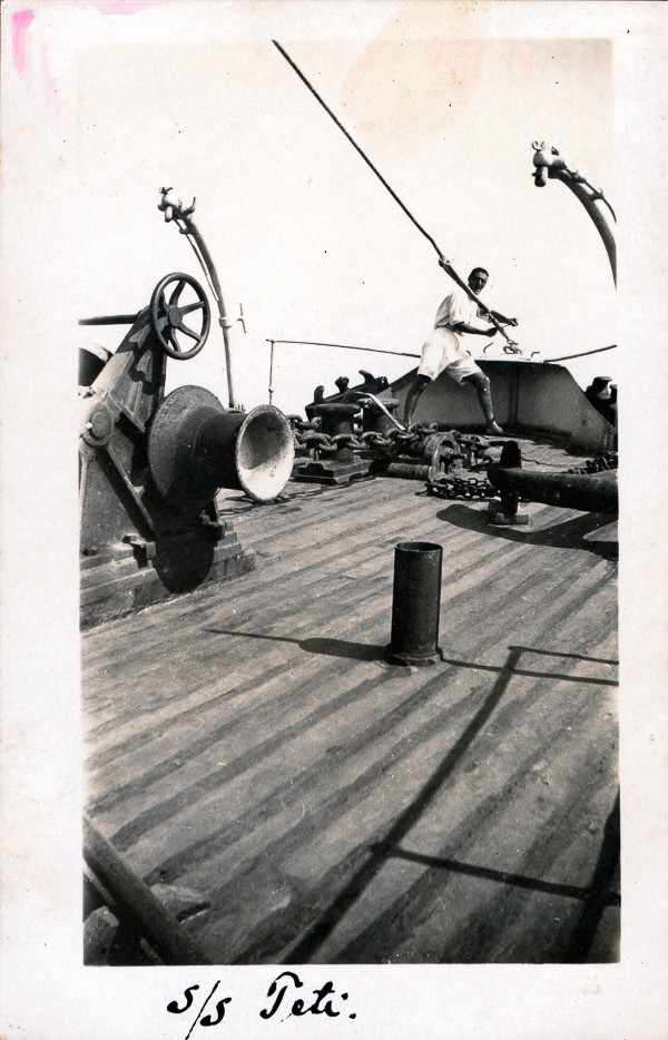
The ship was named the Teti, and belonged to the Italian company Societa Italiana Navigazione Trasporti e Armamenti from Ravenna. Its commander and crew were experienced sailors and were well-known throughout the whole of the Adriatic. They probably wrongly estimated the distance from the shore when they passed by with the ship along the island of Vis and so carelessly ran aground.
It is interesting that the Teti was an old ship which had changed ownership six times. It was built in 1883 in America and in its 47 years of life had covered many thousands of nautical miles. The steamship Teti could not be refloated from the rocks of Mali Barjak because its hull was too damaged. Winter storms destroyed it so much that it soon disappeared from the surface forever.
WRECK CONDITION AND DIVING:
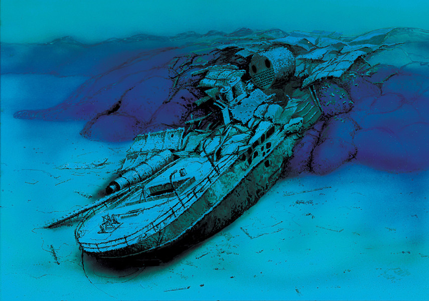
The waters around Komiža are known for their clear sea and abundance of fish, especially around the capes of the Barjak islets. The remnants of the steamship Teti lie within reach of the islet of Mali Barjak and because of the shallow depth it is located in and its condition it presents an ideal location for diving, especially for beginners. According to the year it was built and the look of the wreck we can conclude that the Teti was a steel steamship with two cargo holds and two masts.
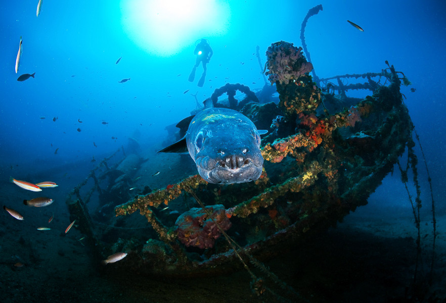
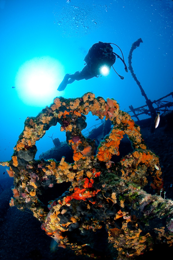
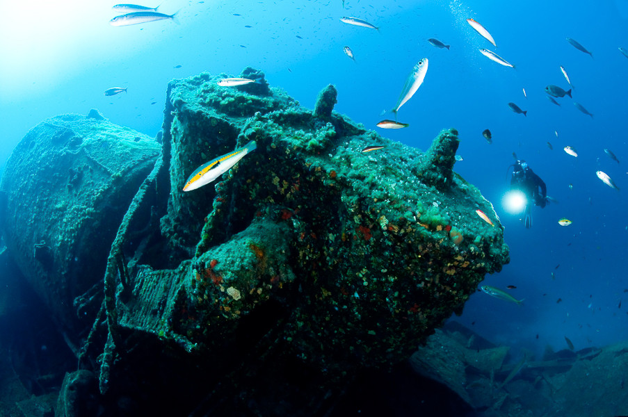
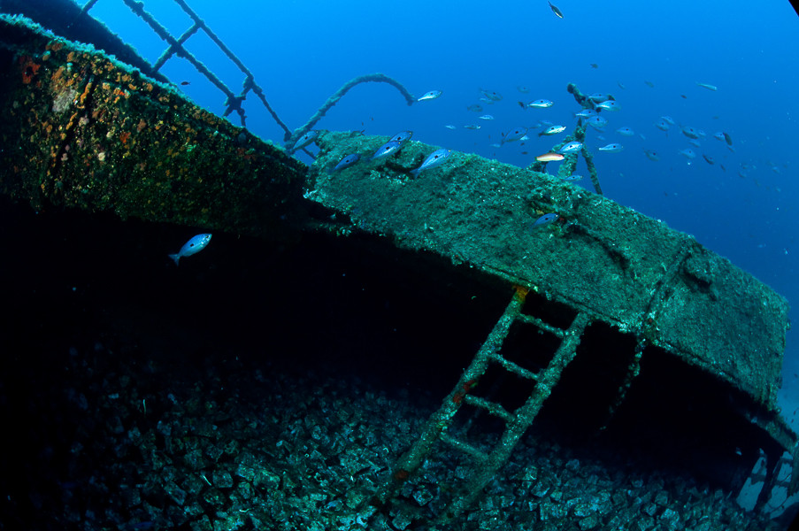
The first traces of the shipwreck begin at a depth of about ten metres from the northern side of Mali Barjak where parts of the bow’s panelling are encountered which rest on the rocky bottom. The remains of the ship lie on a rather gentle underwater slope which gradually descends to a depth of about 35 metres and cross into a sandy bank. There is no bow windlass or anchor, they were probably lifted long ago during an attempt to rescue parts of the ship. Around parts of the panelling piles of granite cubes can be seen, which were the ship’s cargo. Diving towards the depths we come across the steam boiler, behind which there is a well-preserved steam engine around which are scattered parts of the hull’s structure. The main deck and hull at this section do not exist as they have broken into larger pieces. Diving deeper towards the aft sections the ship’s hull and deck are all well-preserved, so that at the stern the hatch of the cargo hold can be seen, through which it is possible to enter without risk and view the interior. In the cargo hold are located more granite cubes for the construction of roads, which at one time were widely used. Through the cargo hold it is possible to reach out all the way to the top of the stern and from it to exist through a smaller, but wide enough opening onto the deck. Over the deck lies the collapsed rear mast the end of which disappears into the sand along the ship’s side. Along the left side of the ship also lies the long funnel, inside which large conger eels lurk. They are very curious and are not afraid of the divers so that they often swim amongst them, peering at them and into their balance vest pockets. Due to this it is necessary to be careful and we do not advise in anyway touching the conger eels, because once a hungry conger eel bit a dive leader by the finger believing that it was offered a fish.
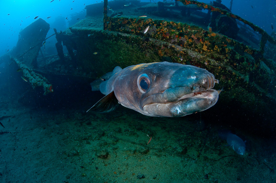
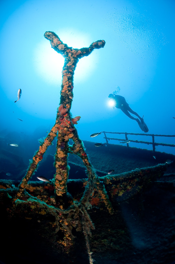
At the end of the stern of the wreck is the auxiliary steering gear with a well-preserved steel wheel rudder, which is an excellent object for photography and filming. The stern of the ship is the most interesting and most impressive part of the wreck around which can always be found masses of tiny fish as well as the occasional grouper and moray eel. The stern is overgrown with orange and purple sponges which gleam with the underwater lights revealing all their beauty. Below the stern we come across the remains of the rudder, but there is no propeller, which tells us that there was a subsequent attempt at rescuing the ship’s equipment. Although the stern’s depth is at 34 metres, due to the excellent visibility from this section almost the whole ship can be seen, of which the bow section ends in the shallows.
We finish the dive with the return towards the bow part of the ship, and then we continue with the ascent following the bottom all the way to the shore of Mali Barjak.
The description and illustrations are a courtesy of Danijel Frka and Jasen Mesić. Buy the whole book here: https://shop.naklada-val.hr/product_info.php?products_id=561
cargo steamship; Societa Italiana Navigazione Trasporti e Armamenti Ravenna, Italy
Built: 1883, John Cockerill shipyard, Hoboken, USA
Sunk: 23rd May 1930 (navigational error – ran aground on the islet of Mali Barjak)
Dimensions: l=72 m, w=8 m, h=4.8 m, 963 t
Coordinates: 43.05333° N, 16.04100° E
Location: Mali Barjak, island of Vis, western cape of Komiža cove
Access: 2/5 access is possible solely by boat (the location is alongside the islet)
Visibility: 5/5 mostly excellent
Current: 5/5 mostly weak
Flora and fauna: 5/5 varied life on and around the wreck, occasionally specimens of large fish (conger eels)
HISTORY:
It was a dark and stormy May night. The residents of Komiža had just dozed-off when, mixed in with the wind, the streets reverberated with the sound of a ship’s siren. Along the coast of the islet of Mali Barjak close to the northwest cape of Komiža Bay a cargo steamship had run aground and was signalling for help. In Komiža the harbourmaster quickly gathered a team of experienced and strong fishermen. In one leut (a traditional fishing boat) they loaded several long ropes and some warm clothing. Then the improvised rescue boat with the full power of the rowers set off out from Komiža. The journey was very difficult, because high “jugo” waves greeted them after the breakwater that they could barely go forward. When they approached the cape of Barjak, they noticed the dark motionless silhouette of the ship, on which the waves were breaking.
After a long lasting struggle with the waves they reached the leeward side of the islet of Veli Barjak; from here they were able to better examine the ship the bow of which was stranded not far from the shore of Mali Barjak. The entire fore section of the ship was stranded on the underwater rocks and the waves which were breaking on the shore of Mali Barjak did not enable the leut to get close to the stranded ship without the danger of breaking itself on the ship’s side. The leut cautiously came closer to the bow section of the ship where after short conversation a rope was thrown. When the crew of the ship secured it to the bow, the fishermen rowed with all their strength towards Veliki Barjak. On the shore of the islet they tied the other end of the rope and tightened it, so that the rescue of the crew could begin. One by one, members of the crew descended into the sea and holding frantically onto the rope, they slowly approached the shore of Veliki Barjak. When all the crew had finally been loaded, the leut sailed for Komiža.
The ship was named the Teti, and belonged to the Italian company Societa Italiana Navigazione Trasporti e Armamenti from Ravenna. Its commander and crew were experienced sailors and were well-known throughout the whole of the Adriatic. They probably wrongly estimated the distance from the shore when they passed by with the ship along the island of Vis and so carelessly ran aground.
It is interesting that the Teti was an old ship which had changed ownership six times. It was built in 1883 in America and in its 47 years of life had covered many thousands of nautical miles. The steamship Teti could not be refloated from the rocks of Mali Barjak because its hull was too damaged. Winter storms destroyed it so much that it soon disappeared from the surface forever.
WRECK CONDITION AND DIVING:
The waters around Komiža are known for their clear sea and abundance of fish, especially around the capes of the Barjak islets. The remnants of the steamship Teti lie within reach of the islet of Mali Barjak and because of the shallow depth it is located in and its condition it presents an ideal location for diving, especially for beginners. According to the year it was built and the look of the wreck we can conclude that the Teti was a steel steamship with two cargo holds and two masts.
The first traces of the shipwreck begin at a depth of about ten metres from the northern side of Mali Barjak where parts of the bow’s panelling are encountered which rest on the rocky bottom. The remains of the ship lie on a rather gentle underwater slope which gradually descends to a depth of about 35 metres and cross into a sandy bank. There is no bow windlass or anchor, they were probably lifted long ago during an attempt to rescue parts of the ship. Around parts of the panelling piles of granite cubes can be seen, which were the ship’s cargo. Diving towards the depths we come across the steam boiler, behind which there is a well-preserved steam engine around which are scattered parts of the hull’s structure. The main deck and hull at this section do not exist as they have broken into larger pieces. Diving deeper towards the aft sections the ship’s hull and deck are all well-preserved, so that at the stern the hatch of the cargo hold can be seen, through which it is possible to enter without risk and view the interior. In the cargo hold are located more granite cubes for the construction of roads, which at one time were widely used. Through the cargo hold it is possible to reach out all the way to the top of the stern and from it to exist through a smaller, but wide enough opening onto the deck. Over the deck lies the collapsed rear mast the end of which disappears into the sand along the ship’s side. Along the left side of the ship also lies the long funnel, inside which large conger eels lurk. They are very curious and are not afraid of the divers so that they often swim amongst them, peering at them and into their balance vest pockets. Due to this it is necessary to be careful and we do not advise in anyway touching the conger eels, because once a hungry conger eel bit a dive leader by the finger believing that it was offered a fish.
At the end of the stern of the wreck is the auxiliary steering gear with a well-preserved steel wheel rudder, which is an excellent object for photography and filming. The stern of the ship is the most interesting and most impressive part of the wreck around which can always be found masses of tiny fish as well as the occasional grouper and moray eel. The stern is overgrown with orange and purple sponges which gleam with the underwater lights revealing all their beauty. Below the stern we come across the remains of the rudder, but there is no propeller, which tells us that there was a subsequent attempt at rescuing the ship’s equipment. Although the stern’s depth is at 34 metres, due to the excellent visibility from this section almost the whole ship can be seen, of which the bow section ends in the shallows.
We finish the dive with the return towards the bow part of the ship, and then we continue with the ascent following the bottom all the way to the shore of Mali Barjak.
The description and illustrations are a courtesy of Danijel Frka and Jasen Mesić. Buy the whole book here: https://shop.naklada-val.hr/product_info.php?products_id=561
INVESTMENTS
 H2O Globe BETA
was successfully backed by an amazing group of diving lovers from all around the world!
