


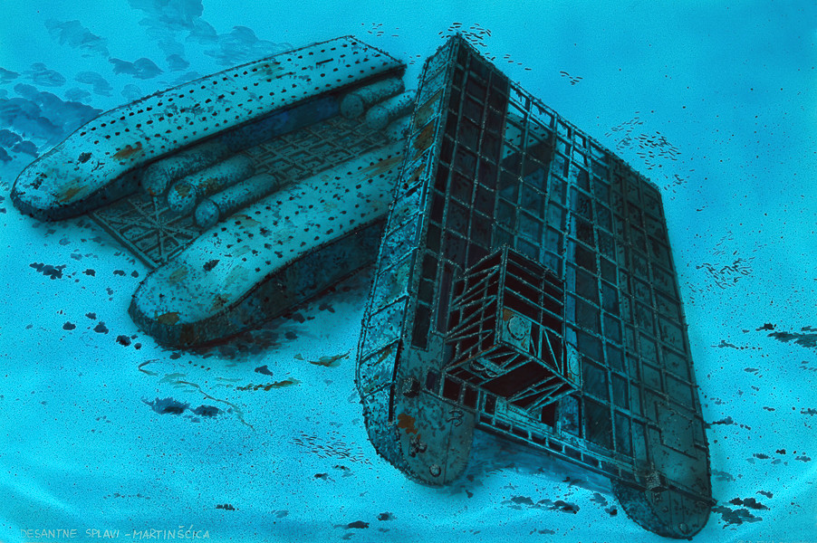

TWIN-HULLED LANDING BARGE
DEPTH: 6 - 10 m
SKILL: Beginner
Pionierlandungsfähre – advance landing ferry; twin-hulled landing barge (Siebelfähre) – two wrecks; probably 1/Ldgs.Pi.Btl. 771 (771st engineering battalion) or 10th landing flotilla
Built: Siebel, Germany
Sunk: probably 1945
Dimensions: l=24.3 m, w=13.9 m
Coordinates: 45.31178° N, 14.47500° E
Location: Northwest cape at the entrance of the cove of Martinšćica, 20 m from the coast
Access: 5/5 access is possible by boat and from the land (from the leisure harbour of Grčevo)
Visibility: 4/5 clear, occasionally very good visibility
Current: 4/5 mostly weak current
Flora and fauna: 3/5 varied life on and around the wreck, only small specimens of fish
HISTORY:
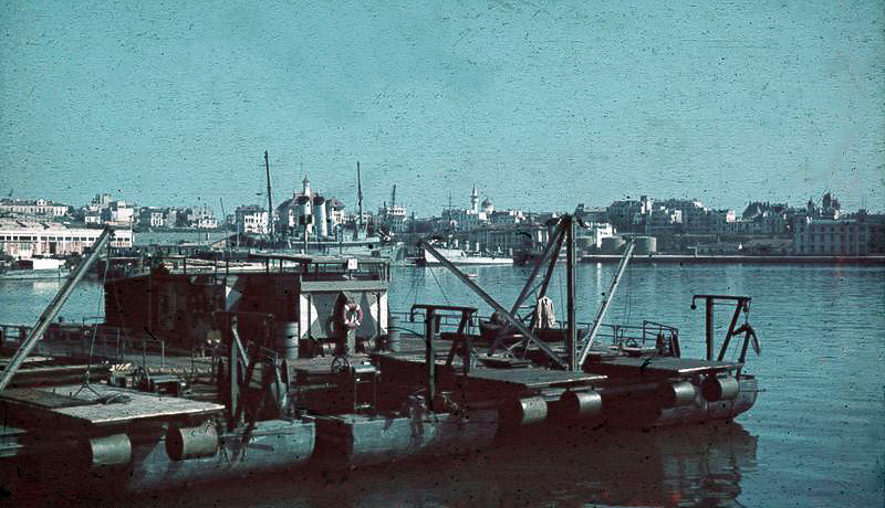
Siebelfähre is the German name given to a prefabricated catamaran style (twin-hulled) landing boat which was used in large numbers by the German Army (Wehrmacht), as well as its navy (Kriegsmarine).
During 1943 the Allies began amphibious operations in North Africa and Italy so the German military was gradually being constrained into more defensive operations and withdrawals. Since they were looking for an urgent solution for the sea transportation of great numbers of people and material, under Siebel's leadership a series of prefabricated boat-pontoon constructions were designed, which with the help of platforms were connected to form one vessel, which could be powered by various types of engines.
In the period from 1942-44 twin-hulled barges were deployed to many battle fronts. Due to their modular construction, they could be quickly transported by rail to distant war zones. The landing barges in question were probably adapted for port services, i.e. used as ship bases. This can be seen in many details: The flat quadrangular bow without any kind of tapering which is not suitable for long voyages, unusually large superstructure with workshops and above all 6 large tanks for increasing buoyancy attached to the underside of the platform which connected both the catamaran style hulls.
It is not known when these two barges were sunk, but some data leads us to the conclusion that they sank at the end of the war, when in the period of February-March 1945 the Allied air forces bombed Rijeka, the port installations and shipyards many times. In Martinšćica the Germans intensively used the small shipyard, which was situated on the western side of the cove, for the repair of landing craft and so these barges were most likely a floating part of the base. After all, the very location of their sinking is in the immediate vicinity of today's shipyard.
WRECK CONDITION AND DIVING:
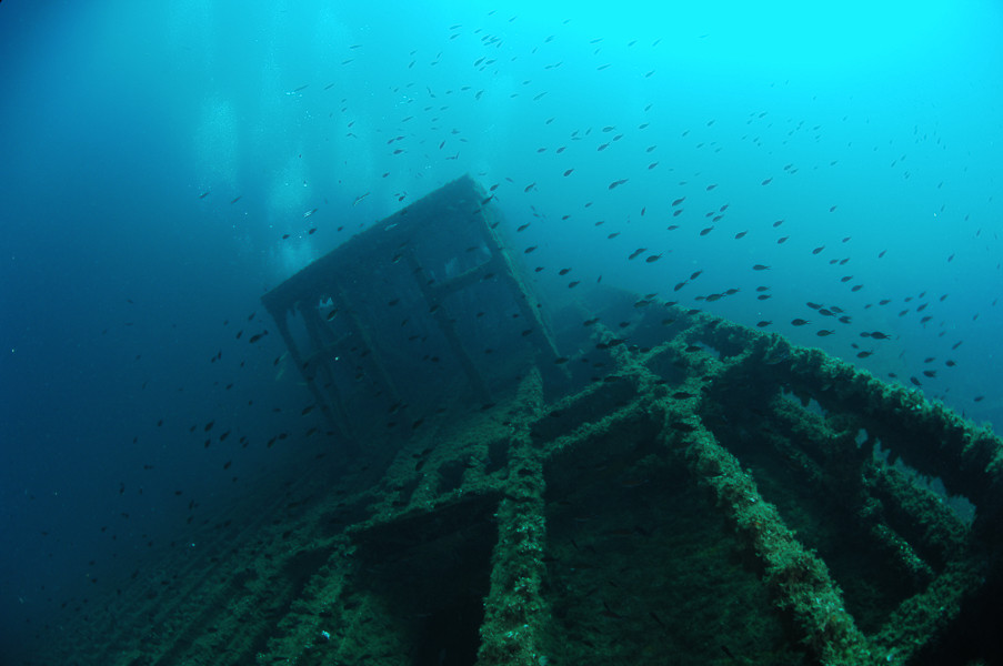
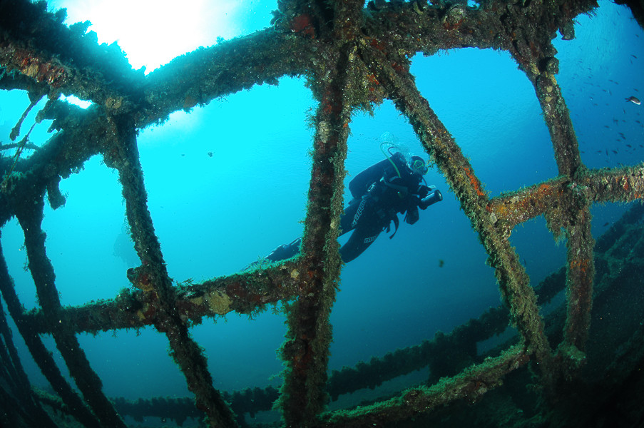
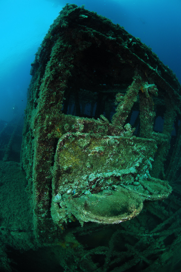
The wrecks are situated on the outer side of the breakwater of the leisure harbour of Grčevo, right at the entrance to the Bay of Martinšćica. At this spot where the depth of the sea is 10 metres, the walls of the breakwater end, and the sandy bottom slowly descends towards the middle of the cove. The hulls of the barges can already be seen from the surface. The first barge is upside-down, whilst the other barge lies in a navigation position, but it is placed crossways in relation to the first and partly leans on its hull. Besides the two relatively well-preserved hulls, not much of the first barge can be seen of its superstructure because it is crushed under the weight of its deck. At the stern section it can be seen that the propeller and axles have been removed, and that only the bearings on the join with the hull remain. The most interesting parts are the six large cylindrical buoyancy tanks which were used to increase the transport capacity of the vessel. The presence of a crane mounted on the deck cannot be excluded.
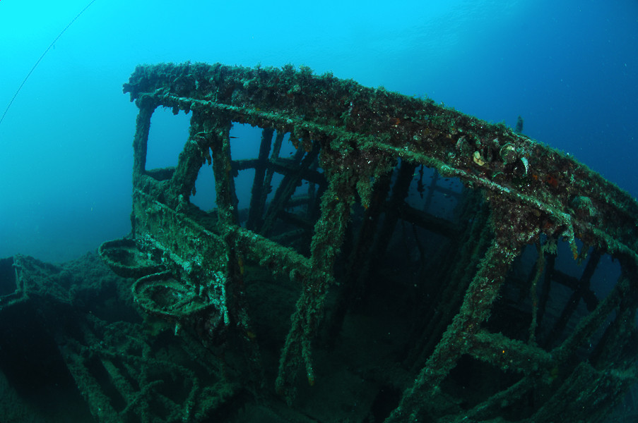
The other barge is in much better condition. It lies obliquely, partly leaning on the hull of the first barge, while its deck and superstructure are preserved. Today the deck looks like a huge steel grid. The superstructure is in a similar condition, which was also constructed from steel, whilst the walls and roof were made of wood. On the upper side of the superstructure can still be seen the steel reinforcements with the mountings on which could be mounted anti-aircraft guns. Swimming along the hull we cannot find any visible sign of damage, so the mystery of how these barges really sank remains.
Even though the location is right in front of the entrance to the industrial zone of the shipyard, around the wrecks diverse marine life flourishes. Marine vegetation has turned the mooring bitts into varicoloured bouquets, a few groupers hide in the shadows under the hull and shoals of damselfish and other small fish which gather around the wrecks occasionally obscure the view of the barges.
The description and illustrations are a courtesy of Danijel Frka and Jasen Mesić. Buy the whole book here: https://shop.naklada-val.hr/product_info.php?products_id=561
Built: Siebel, Germany
Sunk: probably 1945
Dimensions: l=24.3 m, w=13.9 m
Coordinates: 45.31178° N, 14.47500° E
Location: Northwest cape at the entrance of the cove of Martinšćica, 20 m from the coast
Access: 5/5 access is possible by boat and from the land (from the leisure harbour of Grčevo)
Visibility: 4/5 clear, occasionally very good visibility
Current: 4/5 mostly weak current
Flora and fauna: 3/5 varied life on and around the wreck, only small specimens of fish
HISTORY:
Siebelfähre is the German name given to a prefabricated catamaran style (twin-hulled) landing boat which was used in large numbers by the German Army (Wehrmacht), as well as its navy (Kriegsmarine).
During 1943 the Allies began amphibious operations in North Africa and Italy so the German military was gradually being constrained into more defensive operations and withdrawals. Since they were looking for an urgent solution for the sea transportation of great numbers of people and material, under Siebel's leadership a series of prefabricated boat-pontoon constructions were designed, which with the help of platforms were connected to form one vessel, which could be powered by various types of engines.
In the period from 1942-44 twin-hulled barges were deployed to many battle fronts. Due to their modular construction, they could be quickly transported by rail to distant war zones. The landing barges in question were probably adapted for port services, i.e. used as ship bases. This can be seen in many details: The flat quadrangular bow without any kind of tapering which is not suitable for long voyages, unusually large superstructure with workshops and above all 6 large tanks for increasing buoyancy attached to the underside of the platform which connected both the catamaran style hulls.
It is not known when these two barges were sunk, but some data leads us to the conclusion that they sank at the end of the war, when in the period of February-March 1945 the Allied air forces bombed Rijeka, the port installations and shipyards many times. In Martinšćica the Germans intensively used the small shipyard, which was situated on the western side of the cove, for the repair of landing craft and so these barges were most likely a floating part of the base. After all, the very location of their sinking is in the immediate vicinity of today's shipyard.
WRECK CONDITION AND DIVING:
The wrecks are situated on the outer side of the breakwater of the leisure harbour of Grčevo, right at the entrance to the Bay of Martinšćica. At this spot where the depth of the sea is 10 metres, the walls of the breakwater end, and the sandy bottom slowly descends towards the middle of the cove. The hulls of the barges can already be seen from the surface. The first barge is upside-down, whilst the other barge lies in a navigation position, but it is placed crossways in relation to the first and partly leans on its hull. Besides the two relatively well-preserved hulls, not much of the first barge can be seen of its superstructure because it is crushed under the weight of its deck. At the stern section it can be seen that the propeller and axles have been removed, and that only the bearings on the join with the hull remain. The most interesting parts are the six large cylindrical buoyancy tanks which were used to increase the transport capacity of the vessel. The presence of a crane mounted on the deck cannot be excluded.
The other barge is in much better condition. It lies obliquely, partly leaning on the hull of the first barge, while its deck and superstructure are preserved. Today the deck looks like a huge steel grid. The superstructure is in a similar condition, which was also constructed from steel, whilst the walls and roof were made of wood. On the upper side of the superstructure can still be seen the steel reinforcements with the mountings on which could be mounted anti-aircraft guns. Swimming along the hull we cannot find any visible sign of damage, so the mystery of how these barges really sank remains.
Even though the location is right in front of the entrance to the industrial zone of the shipyard, around the wrecks diverse marine life flourishes. Marine vegetation has turned the mooring bitts into varicoloured bouquets, a few groupers hide in the shadows under the hull and shoals of damselfish and other small fish which gather around the wrecks occasionally obscure the view of the barges.
The description and illustrations are a courtesy of Danijel Frka and Jasen Mesić. Buy the whole book here: https://shop.naklada-val.hr/product_info.php?products_id=561


INVESTMENTS
 H2O Globe BETA
was successfully backed by an amazing group of diving lovers from all around the world!
