


TOTONNO
DEPTH: 25 - 51 m
SKILL: Advanced
Totonno (ex-Francesco Imparato, ex-Achille-Bayart, ex-Curacao); cargo steamship; Italy, shipper M. Bottiglieri
Built: 1899 Rijkee, Rotterdam, the Netherlands
Sunk: 15th February 1943 (strayed into a minefield)
Dimensions: l=60.7 m, w=10 m, 729 t.
Coordinates: 42.65189° N, 18.04683° E
Location: Grebeni rocks near Dubrovnik
Access: 2/5 access is possible solely by boat (the location is alongside the islet)
Visibility: 5/5 mostly excellent
Current: 5/5 mostly weak
Flora and fauna: 5/5 varied life on and around the wreck, occasionally specimens of large fish
HISTORY:
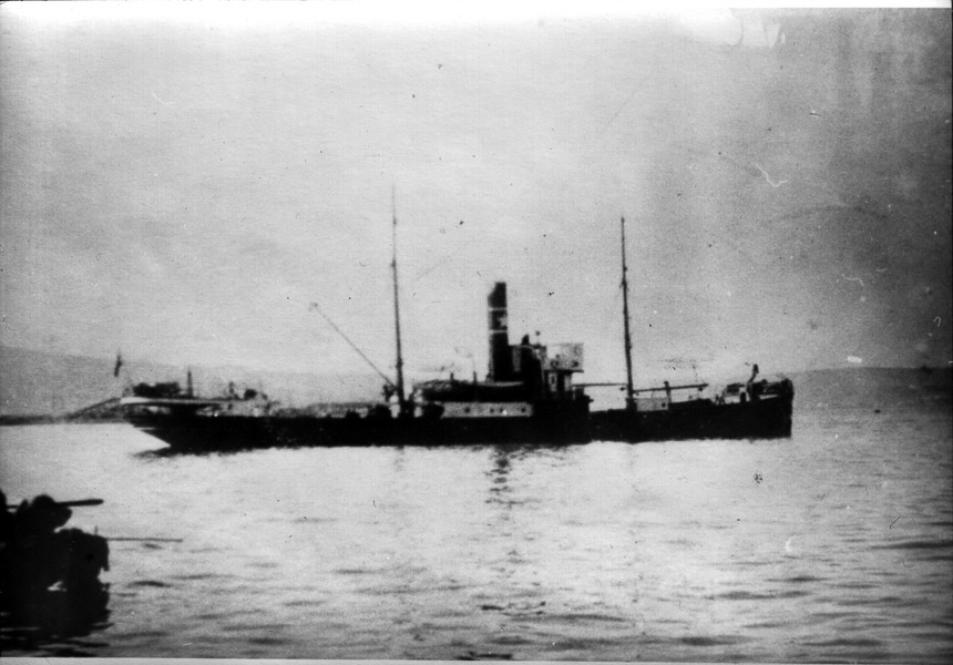
In December of 1899 in the Dutch shipyard Rijkee in Rotterdam, a new cargo steamship the Curacao of 729 tonnes was ceremoniously handed over to the company Koninklijke West-Indische Maildienst. From 1883, this postal company operated the fast sea postal connection of Amsterdam-Paramaribo-Demarara-Trinidad-Curacao, and from 1888 with Port au Prince and New York as well. The steamship Curacao sailed on this route for just over a year. At the end of the First World War in 1918, it was sold to the Italian company B. Albanese who changed its name to Francesco Imparato, and for the new company it sailed until 1930. After that it was sold to the Italian company M. Bottiglieri and gained a new name, the Totonno.
At the beginning of the Second World War the ship was requisitioned for the needs of the Italian Navy as a transportation ship. Under military command it sailed until 15th February 1943, when on its way from Italy loaded with various war materials it sailed into Gruž harbour. During the approach to Gruž harbour, the ship mistakenly sailed too close to the rocks of Grebeni and suddenly came across a mine in an Italian minefield. The mine’s explosion severely damaged the ship at the level of the forward cargo hold, creating a large hole. The commander tried to beach the ship by turning the bow towards Grebeni which was only several hundred metres away, hoping that with the ship’s momentum it would somehow reach the shallower plateau around Grebeni. This plateau at a depth of 10-25 metres extends parallel with Grebeni and it ends towards the depths of a sharp step which forms the rocks, after which the bottom steeply falls to a depth of 45-50 metres. Nevertheless, the Totonno was sinking fast and the bow disappeared underwater in just a few minutes. Touching the sea bottom with the bow at the very edge of the plateau at a depth of some 25 metres, the ship stayed in that position for some time, with the stern which was still above the water, until the sea filled the hull, and then the stern disappeared under the surface. The ship sank transversally in respect of the underwater step, so that the bow leant on the shallows, and the stern on the deeper part of the underwater ledge. When the stern part of the ship finally hit the bottom at a depth of 50 metres, the ship’s hull snapped at a spot just in front of the superstructure, since the construction of the hull was not strong enough to endure the strain with the support being only on the bow and stern. The surviving members of the crew managed to swim and reach the shore of Grebeni, which was only a hundred metres away.
WRECK CONDITION AND DIVING:
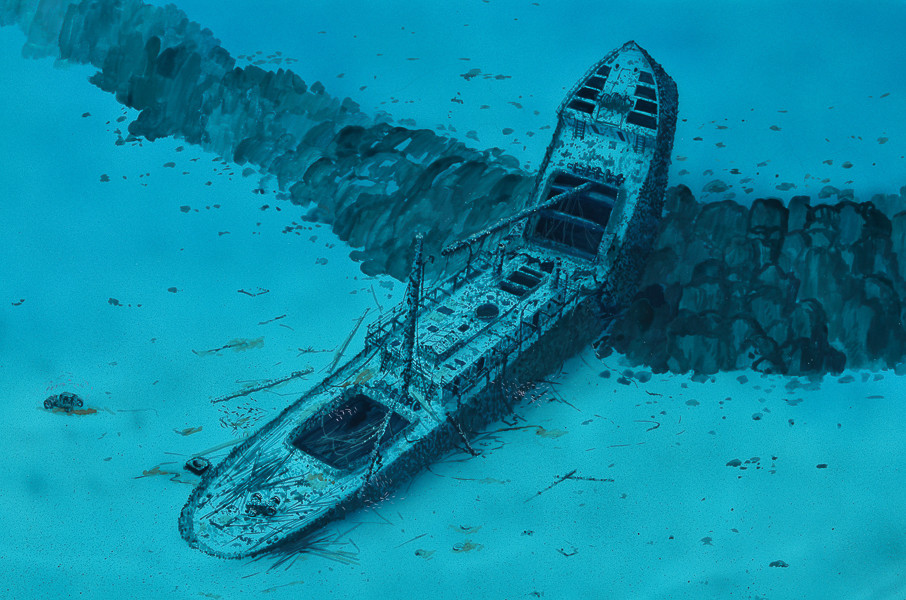
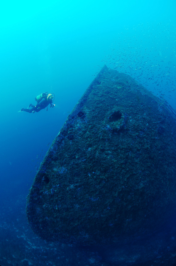
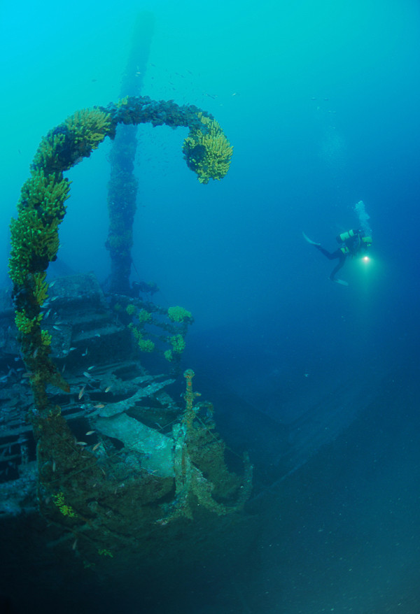
The wreck is about 100 metres NNW from the rocks of Grebeni, near the lighthouse. It can be found relatively easily, as it is promoted as one of not-to-be-missed locations for diving tourists who are brought here by the diving centres of the region, and so a signal buoy has been placed on its prow. Due to the characteristic shape of the seabed, the bow of the wreck is standing upwards at a 50-60 degree angle and leans on the vertical wall of the ridge, while the rest of the ship lies on the sandy seabed in an upright position. Just a few metres down, the bow of the ship can be made out, which looks like it has been placed upright towards the surface. Descending to it we come across the shallowest part of the wreck – the very top of the bow. The depth here is about 20 metres, and the whole bow is ringed with shoals of countless small fish which only move away when we drop down to the top of the bow.
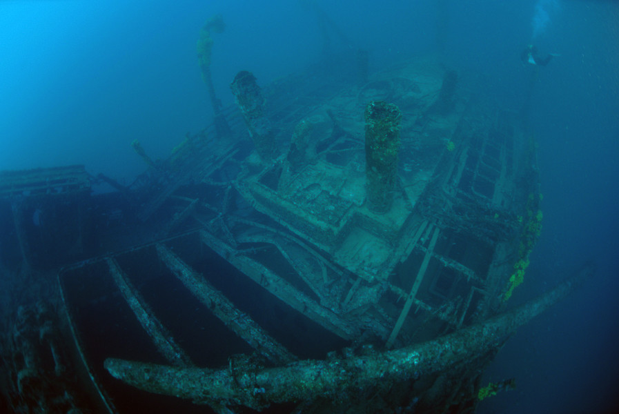
Descending down the deck on the bow we come to the opening of the forward cargo hold. We can see part of the cargo and almost everything is covered with a fine silt. Descending further we come to the spot where the ship looks as though it is split. As with all similar ships of that time, the wheelhouse was wooden and almost nothing remains of it today. Only the metal base of the helm shows the place where the heart of the ship once was and the remains of the foremast. The stern is quite deformed due to the impact with the bottom when the ship sank. Amongst the bent metal plating, on the stern deck lies one small overturned agricultural tractor, the steel wheels of which are turned towards the surface.
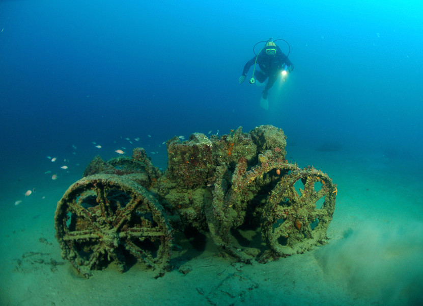
Swimming above the sandy seabed at a depth of about 50 metres, at some twenty metres to the left of the stern, we come across the most beautiful part belonging to the ship – on the light sand there stands another tractor in a position as though it is ready to be driven. It is completely overgrown with sponges of a gentle pink colour, and around it is a shoal of swallowtail sea perches, a beautiful little fish which with its appearance would be an adornment to any aquarium. Returning to the stern, on its left side the anchor of an Italian sea mine can be seen.
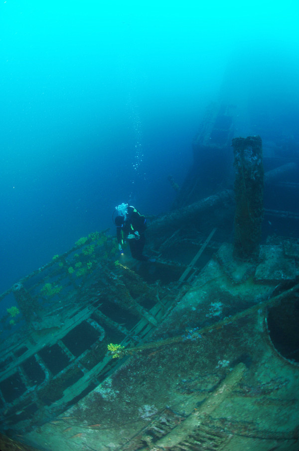
Returning towards the superstructure, we can pass the side corridor along the superstructure, and at the same time peek through some of the doors which are all open. Large groupers can be seen everywhere, as well as an occasional crayfish with its feelers carefully examining the space in front of its hole. It is possible to swim into the engine room taking care not to raise too much mud with our flippers.
We can swim along the side of the bow section all the way to the vertical rocky ridge upon which it is leaning. Under the hull is a large empty space like a tunnel, through which we can dive under all the way to the other side of the ship. From the top of the ridge along the slim and straight bow we can climb up to the anchoring rope which leads to the surface.
The description and illustrations are a courtesy of Danijel Frka and Jasen Mesić. Buy the whole book here: https://shop.naklada-val.hr/product_info.php?products_id=561
Built: 1899 Rijkee, Rotterdam, the Netherlands
Sunk: 15th February 1943 (strayed into a minefield)
Dimensions: l=60.7 m, w=10 m, 729 t.
Coordinates: 42.65189° N, 18.04683° E
Location: Grebeni rocks near Dubrovnik
Access: 2/5 access is possible solely by boat (the location is alongside the islet)
Visibility: 5/5 mostly excellent
Current: 5/5 mostly weak
Flora and fauna: 5/5 varied life on and around the wreck, occasionally specimens of large fish
HISTORY:
In December of 1899 in the Dutch shipyard Rijkee in Rotterdam, a new cargo steamship the Curacao of 729 tonnes was ceremoniously handed over to the company Koninklijke West-Indische Maildienst. From 1883, this postal company operated the fast sea postal connection of Amsterdam-Paramaribo-Demarara-Trinidad-Curacao, and from 1888 with Port au Prince and New York as well. The steamship Curacao sailed on this route for just over a year. At the end of the First World War in 1918, it was sold to the Italian company B. Albanese who changed its name to Francesco Imparato, and for the new company it sailed until 1930. After that it was sold to the Italian company M. Bottiglieri and gained a new name, the Totonno.
At the beginning of the Second World War the ship was requisitioned for the needs of the Italian Navy as a transportation ship. Under military command it sailed until 15th February 1943, when on its way from Italy loaded with various war materials it sailed into Gruž harbour. During the approach to Gruž harbour, the ship mistakenly sailed too close to the rocks of Grebeni and suddenly came across a mine in an Italian minefield. The mine’s explosion severely damaged the ship at the level of the forward cargo hold, creating a large hole. The commander tried to beach the ship by turning the bow towards Grebeni which was only several hundred metres away, hoping that with the ship’s momentum it would somehow reach the shallower plateau around Grebeni. This plateau at a depth of 10-25 metres extends parallel with Grebeni and it ends towards the depths of a sharp step which forms the rocks, after which the bottom steeply falls to a depth of 45-50 metres. Nevertheless, the Totonno was sinking fast and the bow disappeared underwater in just a few minutes. Touching the sea bottom with the bow at the very edge of the plateau at a depth of some 25 metres, the ship stayed in that position for some time, with the stern which was still above the water, until the sea filled the hull, and then the stern disappeared under the surface. The ship sank transversally in respect of the underwater step, so that the bow leant on the shallows, and the stern on the deeper part of the underwater ledge. When the stern part of the ship finally hit the bottom at a depth of 50 metres, the ship’s hull snapped at a spot just in front of the superstructure, since the construction of the hull was not strong enough to endure the strain with the support being only on the bow and stern. The surviving members of the crew managed to swim and reach the shore of Grebeni, which was only a hundred metres away.
WRECK CONDITION AND DIVING:
The wreck is about 100 metres NNW from the rocks of Grebeni, near the lighthouse. It can be found relatively easily, as it is promoted as one of not-to-be-missed locations for diving tourists who are brought here by the diving centres of the region, and so a signal buoy has been placed on its prow. Due to the characteristic shape of the seabed, the bow of the wreck is standing upwards at a 50-60 degree angle and leans on the vertical wall of the ridge, while the rest of the ship lies on the sandy seabed in an upright position. Just a few metres down, the bow of the ship can be made out, which looks like it has been placed upright towards the surface. Descending to it we come across the shallowest part of the wreck – the very top of the bow. The depth here is about 20 metres, and the whole bow is ringed with shoals of countless small fish which only move away when we drop down to the top of the bow.
Descending down the deck on the bow we come to the opening of the forward cargo hold. We can see part of the cargo and almost everything is covered with a fine silt. Descending further we come to the spot where the ship looks as though it is split. As with all similar ships of that time, the wheelhouse was wooden and almost nothing remains of it today. Only the metal base of the helm shows the place where the heart of the ship once was and the remains of the foremast. The stern is quite deformed due to the impact with the bottom when the ship sank. Amongst the bent metal plating, on the stern deck lies one small overturned agricultural tractor, the steel wheels of which are turned towards the surface.
Swimming above the sandy seabed at a depth of about 50 metres, at some twenty metres to the left of the stern, we come across the most beautiful part belonging to the ship – on the light sand there stands another tractor in a position as though it is ready to be driven. It is completely overgrown with sponges of a gentle pink colour, and around it is a shoal of swallowtail sea perches, a beautiful little fish which with its appearance would be an adornment to any aquarium. Returning to the stern, on its left side the anchor of an Italian sea mine can be seen.
Returning towards the superstructure, we can pass the side corridor along the superstructure, and at the same time peek through some of the doors which are all open. Large groupers can be seen everywhere, as well as an occasional crayfish with its feelers carefully examining the space in front of its hole. It is possible to swim into the engine room taking care not to raise too much mud with our flippers.
We can swim along the side of the bow section all the way to the vertical rocky ridge upon which it is leaning. Under the hull is a large empty space like a tunnel, through which we can dive under all the way to the other side of the ship. From the top of the ridge along the slim and straight bow we can climb up to the anchoring rope which leads to the surface.
The description and illustrations are a courtesy of Danijel Frka and Jasen Mesić. Buy the whole book here: https://shop.naklada-val.hr/product_info.php?products_id=561

INVESTMENTS
 H2O Globe BETA
was successfully backed by an amazing group of diving lovers from all around the world!
